


Agro Office Mobile
Deskripsi Agro Office Mobile
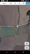
Agro Office Mobile is an innovative mobile application for agriculture. You can have access to the most commonly used features of Agro Office, everywhere you go – in the field, when travelling, or on vacation. We developed the mobile app especially for smart phones and tablets with Android and Apple iOS (iPhone / iPad). If you use Agro Office Maps, BIG BOSS version, you can easily download cadastral maps, satellite pictures, and field boundaries from the server to you smart phone and work off-line.
Agro Office Mobile enables you to:
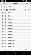
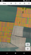
∙ Work with cadastral maps, satellite pictures and field boundaries on-line or off-line
∙ Download field boundaries from the server to the mobile device
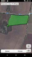
∙ Map fields with the GPS receiver of the mobile device and upload field boundaries to the server
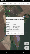
∙ Locate yourself on the satellite picture, cadastral map or field boundary map
∙ Locate parcels or field boundaries in the terrain using your smartphone
∙ Track your farming machinery and equipment, monitor fuel level, calculate work completed (hectares), etc. – all in real time
∙ Receive alarms and notifications, without paying for SMSs
∙ Two-way synchronization – to and from the server
Agro Office Mobile - Informasi APK
Versi APK: 3.1.0Paket: microaccount.agroOfficeMVersi Terakhir dari Agro Office Mobile
Versi lain


Aplikasi pada kategori yang sama

Anda juga mungkin suka...


